This is a work in progress...
I want to expand the narrative text, but for dnow,
we're going to explain, in pictures,
How and why fracking commonly contaminates underground water sources.
Section I. Understanding Potential Energy
First, a physics lesson.
Energy can be translated between forms,
such as translating kinetic energy into potential energy.
But energy can neither be created nor destroyed.
https://en.wikipedia.org/wiki/Conservation_of_energy
This is how a pendulum works:

Another way to visualize this is if we imagine a giant lifting a ball on to a mountaintop:
 |
| With work, Kinetic Energy can be transformed... |
 |
| ... into Potential Energy |
 |
| Potential Energy is a system waiting to release stored energy via the path of least resistance, so we can expect the ball to come rolling down the mountain any time now! |
 |
| A slingshot is another way to transfer kinetic energy into stored (potential) energy. When you apply force and stretch the rubber band, energy is stored in the chemical bonds of the rubber, which is wanting to release and send the payload flying! |
 |
| The reason why a shock absorber on a car works is that an initial shock is absorbed by compressing a spring. This energy is then slowly released due to the action of a gas-charged cylinder and a piston. |
If you put energy into a system, that energy doesn't vanish. It can be translated into other forms, such as heat, or as stored (potential) energy.
Section II. Understanding Water Volumes, Visualizing an underground frac job.
 |
| Ferris Wheel at Pleasure Pier in Galveston, TX is BIG! at ~100' in diameter. |
 |
| Another view of Ferris Wheel at Pleasure Pier in Galveston, TX 100' in diameter. |
 |
| According to Skytruth, the average frac in Pennsylvania is 4.3 Million Gallons of water. http://blog.skytruth.org/2012/09/water-water-everywhere-20-months-of.html 4.3 million gallons is a sphere about 103' in diameter. Let's call it 100'. |
 |
| Cabot's typical horizontal well in 2012 was 4,100 ft long, with 17.7 frac stages (let's call it 18 stages). WPX was the operator in Franklin Forks, but let's assume they are doing about the same. |
 |
| Fracking the Oliver Well Pad, Susquehanna County, PA (Chief) Fracking involves massive pumping trucks all working in concert to generate explosive pressures underground. Photo: Vera Scroggins: http://www.youtube.com/watch?v=TQ1YldfSUV4 |
 |
| Average PA frack = 4.3 Million gallons. 4.3M / 18 stages = 238,888 gallons. This is the volume of a sphere 19.7' in diameter. (Let's call it 20'ft) |
 |
| Now think about this 100' diameter sphere made up of 18 smaller 20' diameter spheres, each holding ~240,000 gallons. Each of these represents one frac stage. |
 |
| A schematic diagram of an 18 stage frac job, using 4.3M gallons of water. Each frac uses as much fluid as sphere 20' in diameter. Assuming a lateral length=4,158', the center point between each frac stage is 231'. NOTE: Image is not to scale. Actual distribution of fluids likely not spherical. |
Hydraulic Fracturing involves massive amounts of fluids, and tremendous energy at the surface. This energy at the surface is converted into heat, and stored, potential energy underground.
Section III. Understanding the local geology near Franklin Forks.
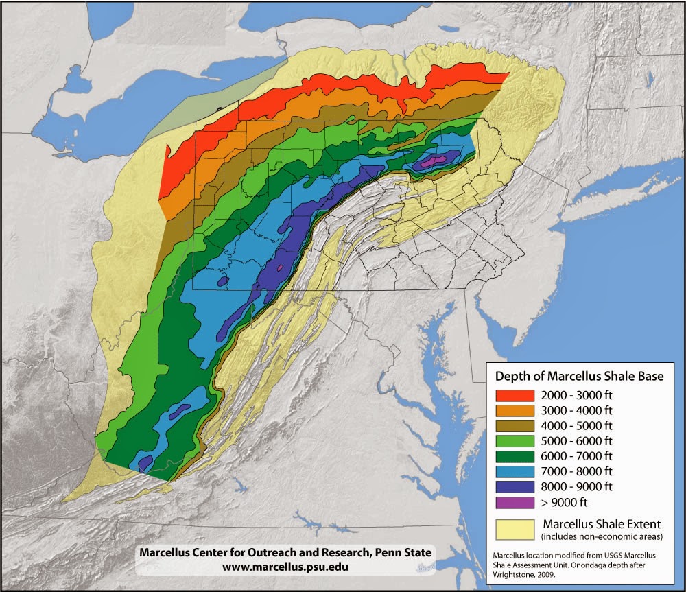 |
| According to maps by the Penn State Marcellus Center for Outreach and Research, the depth of the Marcellus Shale in Northern Franklin Twp. Susquehanna County is 5,000-6,000'ft. |
 |
| According to maps by the Penn State Marcellus Center for Outreach and Research, the depth of the Marcellus Shale in Northern Franklin Twp. Susquehanna County is 5,000-6,000'ft. (detail, Susquehanna County map, with yellow star at Franklin Forks contamination site) |
 |
| The Depue 8H well in Franklin Forks was 4804'ft deep (TVD). Strange: in Franklin Forks, the Marcellus is 5,000-6000'ft. deep. |
 |
| TVD, Total Vertical Depth is the linear vertical depth from the well pad to bottom-of-hole independent of curved path. |
- http://onlinelibrary.wiley.com/doi/10.1111/gwat.12056/pdf
- http://www.gwpc.org/sites/default/files/event-sessions/Molofsky_Lisa2_0.pdf
 |
| According Molofsky, et.al., GSI Environmental, cross section of the area near Franklin Forks. According to this chart, the Depue 8-H at 4,604'ft was drilled into the Tully Sandstone formation, not the Marcellus. |
 |
| According Molofsky, et.al., GSI Environmental, the Upper Devonian strata above the Marcellus in the region of Franklin Forks is marked by "Large Scale Faults", |
 |
| Combining two graphics from Molofsky, et.al., GSI Environmental. Upper Devonian Formation in this area marked by "Large Scale Faults" |
 |
| "Large Scale Faults" in upper Devonian strata near Franklin Forks. (from Molofsky, et.al., GSI Environmental) |
The Upper Devonian strata above the Marcellus near Franklin Forks, in Susquehanna County PA is marked by Large Scale Faults. The shale depth in this area is between 5,000 and 6,000 ft. HOWEVER-- the operator in the area, WPX (Williams Company) drilled one early well, the Depue 8H, only to 4,604', which according to the above charts, seems to be the Tully Sandstone formation, not Marcellus.
Section IV. Putting it all together
According to this article by Haliburton's Kevin Fisher, fractures commonly can extend 1,500' above the horizontal well bore:
http://www.halliburton.com/public/pe/contents/Papers_and_Articles/web/A_through_P/AOGR%20Article-%20Data%20Prove%20Safety%20of%20Frac.pdf
 |
| Haliburton's Kevin Fisher reveals that fractures can extend >1,500'ft above the horizontal bore depth. (July 2010, AOGR) |
Matt and Tammy here say their well is ~160' deep:
http://www.youtube.com/watch?v=af0HAhMrxlA
3104'ft - 160'ft = 2944'ft ==> This is all that fluids/gas must travel to contaminate the aquifer.
This is only 3x the distance reported in Fisher's data as being observed.
And in Franklin Forks, this was through the Upper Devonian layer which was marked by "Large Scale Faults".
 | |
| According Molofsky, et.al., GSI Environmental, the Upper Devonian strata above the Marcellus in the region of Franklin Forks is marked by "Large Scale Faults", as well as intra-layer Detachment / Decollement zones. |
 |
| Each frac stage releases ~240,000 gallons into the surrounding rock. This volume is equal to a sphere ~20' in diameter. |
 |
| Fluids injected want to find a path of least resistance back to the surface. |
 |
| According Molofsky, et.al., GSI Environmental, the Upper Devonian strata above the Marcellus in the region of Franklin Forks is marked by "Large Scale Faults", so these could be the path of least resistance for methane and fluids under extreme pressure to return to the surface and contaminate shallow aquifers. |
 |
| At 4,600'ft down, the hydrostatic pressure alone is ~3,500 psi. This does not include the lithostatic or overburden pressure, caused by the weight of the rocks. I'd estimate the combined static pressure at that depth is about 7,000-10,000 psi. This is approximately the pressure of a fuel-air bomb.Note that the hydraulic fluids must overcome this static pressure in order to fracture the rock. This is why the fluid pressures underground are typically ~15,000 psi. (many industry sources cite this number) This pressure gradient creates stored (potential) energy in the injected fluids. |
 |
| The pressures involved in hydraulically fracturing rock are similar to a fuel-air bomb. |
 |
| Fluids injected at these depths contain stored (potential) energy, which wants to release, by moving up through the pressure gradient into areas of lesser pressure (like shallow, water-bearing strata). It's like a ball on top of an inverted mountain. |
The energy expended at the surface is translated into stored (potential) energy in the fluids, which want to release this energy by returning to the surface via the Path of Least Resistance, which is likely natural faults and fissures in the surrounding geology.
V. Conclusions:
|
| ||||
|
|


Far from being a fringe scenario, water contamination from the drilling operations in Franklin Forks seems likely, once we understand the geology and the physics.
Extreme pressures are induced into large volumes of fluid underground by expending tremendous energy at the surface. Like the energy transferred into the rubber band of a slingshot, or like lifting a heavy weight up, this energy is not lost, but STORED.
The "charged" fluids pumped underground do not want to stay there, and will find the way back to the surface using the path-of-least resistance, which in the case of Franklin Forks, is likely to be the fault-network in the Upper Devonian formation which lies above the Marcellus.
No comments:
Post a Comment